
Project Overarching Objective:
To develop an integrated network of advanced water sensors to acquire real-time, high-frequency water quality data that will advance our understanding of the drivers of local and regional water quality, and in concert use the fields of experimental economics and agent-based modeling to determine how stakeholders as individuals and groups respond to this new technology.
Fundamental Research Questions:
1) What is the impact of climate variability on water quality for watersheds with different land uses extending across the north-south gradient (VT to DE)?
2) Do high-frequency water quality data provide valuable information and insights to stakeholders and thus lead to better and time efficient decision making?
High-frequency spatially extensive data generated by our sensor network for a suite of watersheds with different land uses and landcover extending along a north-south gradient (VT-RI-DE) will allow us to examine natural and social science hypotheses that would be difficult to address with discrete water quality data such as:
1. There are important high-frequency (sub-daily) patterns in oxygen, carbon, nitrogen, and phosphorous that are obscured by traditional mid-frequency (weekly or monthly) sampling and that differ by land cover, location in the N-S gradient, and stream reach.
2. Regional climate-induced disturbances that would otherwise be difficult to sample continuously are imprinted and detectable across the entire sensor array, however, their particular manifestation in time-series water quality data is site-specific due to variable antecedent conditions and different landscape environments across the network.
3. Local and regional differences of study watersheds (VT-RI-DE) in land use, topography, geology, geomorphology and ecology, when coupled with high-frequency nested water data, will allow us to determine how individual watershed features amplify or dampen the hydrologic and water quality responses (magnitude, intensity, and duration) to weather and climate variability.
4. Private individuals, businesses and public institutions will alter their water and land management decisions (timing, extent, intensity, and/or location) when better water resource information is available, but the responses will differ depending on institutional settings and risk preferences.
5. High-frequency data coupled with innovative data visualization will improve our ability to assess risk and evaluate management options and make time efficient decisions. Response will be influenced by institutional settings, risk preferences, individual perceptions and behavior of endusers.
Proposed NEWRnet Sensor Locations
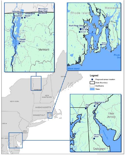
More information about NEWRnet can be found at the NEWRnet website: http://newrnet.org
![]()
The NEWRnet Social-Ecological Gaming and Simulation (SEGS) Lab is a transdisciplinary research lab focused on modeling and simulating Social-Ecological Systems (SESs) from a complex systems perspective by drawing on a range of data sources from simple metadata to "big data" and thick description. A unique feature of the SEGS lab is its focus on the design and implementation of a variety of experimental games and computational models. The SEGS lab team aims at forging new partnerships at state, national and international scales with scholars and practitioners working in this fast-growing and emergent area of research and practice at the nexus of social and behavioral sciences, and ecology.
For more information about the SEGS lab, please visit:
https://segs.w3.uvm.edu/